


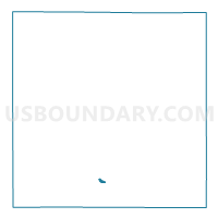
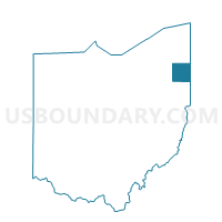
NILES CITY 4E Voting District, Trumbull County, Ohio
About
Outline

Summary
| Unique Area Identifier | 652764 |
| Name | NILES CITY 4E Voting District |
| County | Trumbull County |
| State | Ohio |
| Area (square miles) | 0.19 |
| Land Area (square miles) | 0.19 |
| Water Area (square miles) | 0.00 |
| % of Land Area | 99.74 |
| % of Water Area | 0.26 |
| Latitude of the Internal Point | 41.18369310 |
| Longtitude of the Internal Point | -80.78150440 |
Maps

Graphs
Select a template below for downloading or customizing gragh for NILES CITY 4E Voting District, Trumbull County, Ohio


Neighbors
Neighoring Voting District (by Name) Neighboring Voting District on the Map
- NILES CITY 4C Voting District, Trumbull County, OH
- NILES CITY 4D Voting District, Trumbull County, OH
- NILES CITY 4G Voting District, Trumbull County, OH
- WEATHERSFIELD TWP A Voting District, Trumbull County, OH
- WEATHERSFIELD TWP K Voting District, Trumbull County, OH